Located in Southeast Asia, Burma is one of the most beautiful countries I've ever seen.


Geography of Burma
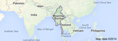
Geographic Coordinates: 22.00° N, 96.00° E
Total area: 676,578 km2 (261,228 square miles)
Land area: 261,228 sq. miles
Water area: 7,994 sq. miles
Size compared to U.S. territory: 0.08 (the U.S. is 11.94 times as big)
Size ranking compared to all countries: 40
Countries that share a border: Bangladesh (West), India (Northwest), China (Northeast), Laos (East), Thailand (East)
Bordered bodies of water: Bay of Bengal (Southwest), Andaman Sea (South)
Total distance of all land boundaries: 5,876 kilometers (3,651 miles)
Total distance of coastline: 1,930 kilometers (1,197 miles)
Climate: Monsoon tropical, very high humidity levels, high rainfall levels, the average temperature ranges from 72°- 81° degrees Fahrenheit. There are three seasons: the monsoon (or rainy) season lasting from May to October, the cool season lasting from November to February, and the hot season lasting from March to April. Higher elevations receive a lot of snow and bad weather.
Terrain: There are many mountain ranges, most of the mountains go run the Western border along India and Bangladesh. Although there are many rivers flowing through Myanmar, there are four main rivers (Ayeyarwady, Thanlwin, Chindwin, Sittaung) usually flowing North to South. There is an array of plateaus, canyons, lakes, caves, volcanos (inactive), a few monoliths, and 8 desserts.
Lowest point of elevation: Andaman Sea 0 m
Highest point of elevation: Hkakabo Razi 5881 m (19,295 feet)
Natural disasters: There are 9 recorded cyclones in the history of Myanmar. The worst one, occurred in 2008, with a total of 138,366 deaths, Cyclone Nargis (134 mph winds) was the worst recorded natural disaster in Myanmar's history. There have also been floods and bad storms.
Environmental issues: Currently going through deforestation, industrially polluted air, soil, and water.